Brief Summary (4:45 PM Update):
PPD Threat:ATL (15%)
Delay Threat: ATL (35%),CHW (20%), KC (10%), STL (20%)
Good Hitting Environments: ATL, KC, STL, AZ, COL
Poor Hitting Environments: TB, LAA
Forecasting Analysis:
CIN@ATL
Looks alot better than just a few minutes ago!
This was the scene from about an hour ago:
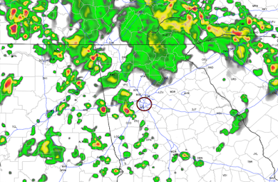
Pop-up showers and tstorms, oh so common in the Southeast during the summer, will be around the region this evening. Here is what the radar could look like at 7 PM:
Pretty darn wet looking, certainly a bit worrisome! LOW TO MAYBE MODERATE CHANCE OF PPD OR OF ANY TYPE OF DELAY(S)
The reason for the optimism is because by 8 PM the radar should look like this:
The reason for the optimism is because by 8 PM the radar should look like this:
DET@CHW
Current radar:
So the rain is not overly heavy or steady as the line of rain is forecast to be broken and that is what the radar is showing right now too. LOW CHANCE OF A PPD; LOW TO MAYBE MODERATE CHANCE OF SOME TYPE OF DELAY(S)
CLE@KC, HOU@STL
Showers and tstorms will be scattered across the Plains this evening. Here is what the radar may look like around scheduled 1st pitch for KC:
Doesn't look too wet, either on radar or via simulated radar. VERY LOW CHANCE OF PPD, LOW CHANCE OF ANY TYPE OF DELAY(S)
For STL here is what 8 PM is forecast to look like:
Yikes! We have a major line of thunderstorms approaching from the west. Where should this line be at 9 PM? Well let's take a look:
And finally at 10 PM:
So it seems like a line of thunderstorms will approach them but weaken after the game has started.
Yikes! We have a major line of thunderstorms approaching from the west. Where should this line be at 9 PM? Well let's take a look:
And finally at 10 PM:
So it seems like a line of thunderstorms will approach them but weaken after the game has started.
LOW CHANCE OF PPD, LOW TO MODERATE CHANCE OF ANY TYPE OF DELAY(S)
NYY@COL
We should be good to go as both the radar and simulated radar is very quiet.


No comments:
Post a Comment