Wednesday, April 27, 2016

MLB DFS Weather Wednesday April 27th

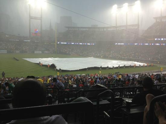
                                       Hopefully we will not have to see this tonight

Brief Summary (6:45 PM EDT update):


PHL at WSH is not a concern. VERY LOW CHANCE OF A PPD OR DELAY

MIL at CHC and CLE at MIN will be affected by rain. Let's look at both locations at the same time with the current radar and simulated radars for this evening:

Current:

It is already raining in Minneapolis and Chicago. Rain before scheduled 1st pitch always makes me leery as the people making the decisions at the stadium look out the window and say, "Wow, it is really wet out there!"

The other factor that should be factored in as well is that is it is cold and windy in both locations, downright miserable to be outside in both locations. The people making decisions probably think, "Man, I would not want to sit in the stands on a night like tonight" and thus lean towards cancelling the game.


But let's see where this rain is forecast to do:

8 PM:

9 PM:
10 PM:
Latest trends say this rain is going to lift north of Minneapolis this evening by about 9-9:30 PM...so that makes the decision to cancel or just delay the start even more difficult in the Twin Cities.

The rain will stick around longer in Chicago but it is not quite as heavy nor as steady there. So no slam dunk in the Windy City either.

Taking all of this in, it is going to be raining before the game, it is cold, it is windy and that rain will last through at least through the 1st couple of scheduled hours of the game:

MODERATE CHANCE OF DELAY AND/OR PPD IN MINNESOTA WHILE MODERATE TO HIGH IN CHICAGO.
Hopefully we here soon that they they are, in fact, cancelling the games so we know for sure

Final thinking is that the Cubs will PPD while the Twins try to play


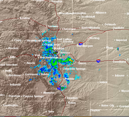
PIT at COL will feature more chilly rain rotating around the region but there should be enough "holes" in the precipitation to not be a huge worry. LOW CHANCE OF A PPD/DELAY(S)
8 pm simulated radar tells the story: not much to worry about here

Good Hitting Environment:

You can never ignore the thin air in COL but it will continue to be chilly with a wind blowing in. 


Poor Hitting Environments:

If they do play in CHC and also in MIN, there will be a moderate breeze blowing in and temps will be chilly. 


PHL at WSH 7:05: SEE BRIEF SUMMARY ABOVE. Wind NE becoming SE 6-12 mph which blows 1st in from right and then out to left. The wind is a 4 becoming a 6. Temps in the mid to upper 50s. Air density is a 5.

CHW at TOR 7:07: Chilly temperatures will continue to keep the roof closed. 

ATL at BOS 7:10: WSW wind 7-14 mph which blows out to right. The wind is a 6. Temps near 60 falling into the mid 50s. Air density is a 5.

OAK at DET 7:10: NE wind 5-10 mph which blows from left to right. The wind is a 5. Temps in the low to mid 50s falling into the mid to upper 40s. Air density is a 4 becoming a 3.

CIN at NYM 7:10: Wind light and variable, which is a 5. Temps in the mid to upper 50s falling into the low 50s. Air density is a 5.

BLT at TB 7:10: Dome.

NYY at TEX 8:00: West wind 5-10 mph becoming light and variable. The wind blows out to left-center early which is a 6 but becomes a 5 as the game goes on. Temps in the low 80s falling to near 70. Air density is a 7.

MIL at CHC 8:05: SEE BRIEF SUMMARY. Wind ENE 10-20 mph which blows in from right. The wind is a 2 or a 3. Temps in the low to mid 50s falling into the upper 40s. Air density is a 4.

CLE at MIN 8:10: SEE BRIEF SUMMARY ABOVE. Wind NE 10-20 mph which blows in from left-center. The wind is a 2 or a 3. Temps generally near 50. Air density is a 4.

PIT at COL 8:40: SEE BRIEF SUMMARY ABOVE. Wind NE 10-20 mph which blows in from right. The wind is a 2 or a 3. Temps in the low 50s falling to near 40. Air density is a 10.

STL at AZ 9:40: Continued rather pleasant so the roof should be open. Wind WSW 8-16 mph which blows from right to left. The wind is a 5. Temps in the low to mid 80s falling into the low to mid 70s. Air density is an 8.

KC at LAA 10:05: WSW wind 10-20 mph which blows out to right-center. The wind is a 7 or a 8. Temps in the mid 60s falling into the low 60s. Air density is a 6.

HOU at SEA 10:10: A few showers around may keep the roof closed. If the roof is open, the winds will be NW 5-10 mph which blows from left to right. The wind will be a 5. Temps near 60 falling into the mid 50s. Air density is a 5.

MIA at LAD 10:10: WSW wind 10-20 mph which blows out to right-center. The wind is a 7 or a 8. Temps in the mid 60s falling into the low 60s. Air density is a 6.

Tuesday, April 26, 2016

MLB DFS Weather Tuesday April 26th

                                  There is a risk for severe weather tonight for NYY at TEX

Brief Summary (6:50 PM Update): 

Latest thoughts (nothing changed below:)

WSH IS GOOD TO GO AND WHILE THERE IS A SMALL RISK IN COLORADO AND A SMALL TO MODERATE RISK IN TEXAS, I AM GOING OUT ON THE LIMB TO SAY GO AHEAD AND PLAY ANYONE FROM THESE 3 GAMES!!

Let's start in our Nation's Capital for PHL at WSH.  As the map shows, most of the thunderstorm activity should stay north and west. As the game goes on....some scattered thunderstorms will sink towards them but all in all this trend continues to be GOOD NEWS.

 Conclusion: A LOW CHANCE OF A PPD AND DELAY(S), DELAY THREAT INCREASES A BIT LATER IN THE GAME WE GO.

Here are a few simulated radars:
7PM:
8 PM:
So that looks pretty innocent! A cold front basically sitting right on top of them makes me feel slightly less optimistic than what the images show though.


VERY WIDELY SCATTERED T-STORMS for BOS at ATL. Almost not even worth mentioning. Worst case scenario is a DELAY.  

NYY at TEX (Update at 6:40 PM: T-storms looking ever so quicker but still looks to me they are dry until about 9:30 PM) will see a moderate risk of thunderstorms this evening, some which may be severe. Good news: the worst of the severe outbreak should be to their north and west and rather late too (after 10:30 to 11). Also, by the nature of thunderstorms, it will not be raining all the time and not every location will see severe weather or even any rain at all. Bad news: you never want to see the threat of severe weather at any outdoor event. Local and stadium officials will be sensitive to this weather event since it will be all over the news. CONCLUSION: LOW PPD RISK; MODERATE DELAY RISK. 

Simulated radars 
8 PM:
9 PM:
10 PM:
11 PM:
For those that do not know, the stadium is basically halfway between the DFW and FTW on the map. Hard to see, I know. The other way you can judge where the stadium: it is about halfway between the two "loops" around the cities of Dallas and Fort Worth.

ALL SAID AND DONE, THE THUNDERSTORMS MAY WAIT UNTIL VERY LATE IN THE GAME TO MAKE AN APPEARANCE. 


PIT at COL: PPD RISK LOW; DELAY RISK LOW; DELAYED START NOW LOW.

Current radar (6:00 PM): 


http://radar.weather.gov/radar.php?rid=FTG&product=N0R&overlay=11101111&loop=yes 

GREAT NEWS! The rain has sunk away from the city...so I am VERY optimistic!

Simulated radars:
8 PM
9 PM
So the simulated radars say do not worry....but the current radar has me worried! Will continue to update!  

Good Hitting Environments:

-You can never ignore the extremely low air density at Coors Field for PIT at COL but tonight will feature chilly temperatures and a wind blowing in.
-Strong wind blowing out to center for SD at SF.

Poor Hitting Environments:

-Very chilly for OAK at DET and CLE at MIN. 
-Wind blowing in will combine w/cool temperatures to make it a tough places to hit for both CIN at NYM and MIL at CHC

PHL at WSH: SEE BRIEF SUMMARY ABOVE. Winds SW becoming NW at 8-16 mph which blows 1st out to center and then from left to right. The wind is a 7 becoming a 5. Temps in the mid 70s falling into the upper 60s. Air density is a 7 becoming  6.

CHW at TOR: Chilly temperatures will continue to keep the roof closed. 

OAK at DET 7:10: Wind NNE 7-14 mph which blows out to right. The wind is a 6. Temps near 50 falling into the mid 40s. Air density is a 3 becoming a 2.

BOS at ATL 7:10: SEE BRIEF SUMMARY ABOVE. Wind SW 4-8 mph which blows out to left-center. The wind is a 6. Temps in the mid 70s dropping into the low 70s. Air density is a 7.

CIN at NYM 7:10: NE wind 8-16 mph which blows in from center. The wind is a 3. Temps in the mid to upper 50s falling into the low 50s. Air density is a 5 becoming a 4.

BLT at TB 7:10 Dome

NYY at TEX 8:05: SEE BRIEF SUMMARY ABOVE. SSE wind 12-25 mph which blows in from right-center. The wind is a 2. Temps generally in the mid to upper 70s. Air density is a 7. 

MIL at CHC 8:05: NE wind 10-20 mph which blows in from center. The wind is a 2 or a 3. Temps only in the upper 40s falling into the low to mid 40s. Air density is a 2.

CLE at MIN 8:10: NE winds 8-16 mph which blows in from left. The wind is a 3. Temps in the mid to upper 40s. Air density is a 3.

PIT at COL 8:40: SEE BRIEF SUMMARY ABOVE. N winds 10-20 mph will blow in from center. The wind is a 2 or a 3. Temps generally near 40. Air density is still a 10 though.

STL at AZ 9:40: The retractable roof will likely be open. Wind WSW 5-10 mph which blows from right to left. The wind is a 5. Temps in the upper 70s falling into the low 70s. Air density is an 8 becoming a 7.

KC at LAA 10:05: Wind WSW 8-16 mph lessening to 5-10 mph which blows out to right. The wind is a 7 becoming a 6. Temps in the mid 60s falling to near 60. Air density is a 6 becoming a 5.

HOU at SEA 10:10: Chilly temperatures may keep the roof closed. If it is open: Winds SW 5-10 mph which blow out to center. The wind is a 6. Temps in the upper 50s falling to near 50. Air density is a 4 becoming a 3.

MIA at LAD 10:10: Wind WSW 8-16 mph lessening to 5-10 mph which blows out to right. The wind is a 7 becoming a 6. Temps in the mid 60s falling to near 60. Air density is a 6 becoming a 5.

SD at SF 10:15: West wind 20-30 mph which blows out to center. The wind is an 8. Temps near 60 falling into the mid 50s. Air density is a 5. 


Monday, April 25, 2016

MLB DFS Weather Monday April 25th

Hopefully, this scene will not be repeated tonight in Detroit

Brief Summary (7:45 PM EDT Update):

Timimg still looks OK in Detroit! They should get this one in!

OAK at DET will be generally dry this evening. A line of severe thunderstorms will approach the area during the game. Timing is critical here as to when the severe weather is forecast to move through.

The Severe Prediction Center's (SPC) forecast for this evening:


Let's see what the simulated radars look like:

 7PM: 

8 PM:
9PM:
10 PM:


I see some of my fears being realized, things ARE speeding up a little bit. 

 Let's go with LOW CHANCE OF A PPD, MODERATE CHANCE OF DELAY(S) starting as early as 9 pm but probably waiting to almost 10 PM. It looks like they should have about 2-3 dry hours to play!!! Timing is critical!


BOS at ATL, NYY at TEX and PIT at COL will see a very small chance of a thunderstorm affecting the stadiums. So small that I debated even mentioning it. VERY LOW CHANCE OF A PPD/DELAY(S). I will break down the simulated radars for all 3 as we get closer to 1st pitch.

CLE at MIN will see some lingering showers this evening.  VERY LOW CHANCE OF A PPD, LOW CHANCE OF A DELAY(S).

Good Hitting Environments:

-PIT at COL will have the obvious advantage of the low air density but a strong wind blowing out to left-center will help batters as well.
-A stronger than normal wind will blow out to rightfield for KC at LAD.
-Strong West winds will blow out in the 3 California locations in SF, LAD and LAA. 

Poor Hitting Environments:

-Chilly temperatures and a bit of a wind blowing in  makes it tough to hit for OAK at DET. 
-Still relatively chilly in the Northeast for CIN at NYM.  

CHW at TOR 7:07: The roof will be closed. 

OAK at DET 7:10: SEE BRIEF SUMMARY ABOVE. ESE wind 6-12 mph blows in from left. The wind is a 4. Temps in the mid to upper 50s. Air density is a 5.


BOS at ATL 7:10: SEE BRIEF SUMMARY ABOVE. SSE wind 5-10 mph which blows out to left. The wind is a 6. Temps in the low 70s falling into the mid/upper 60s. Air density is a 7 becoming a 6.

CIN at NYM 7:10: Wind E at less than 5 mph which blows in from right. The wind is a 5. Temps in the low 60s falling into the upper 50s. Air density is a 5.

BLT at TB: Dome.

NYY at TEX 8:00: SEE BRIEF SUMMARY ABOVE. Wind SSE 10-20 mph which blows in from right. The wind is a 2 or a 3. Temps in the low 80s falling into the upper 70s. Air density is a 7.

CLE at MIN 8:10: SEE BRIEF SUMMARY ABOVE. Wind N 7-14 mph which blows from left to right. The wind is a 5. Temps in the low 60s falling into the mid to upper 50s. Air density is a 6 becoming a 5.

PIT at COL 8:40: SEE BRIEF SUMMARY ABOVE. Wind SSE 12-25 mph lesseningtom10-20 mph which blows out to left-center. Temps in the mid 60s falling into the low to mid 50s. Air density is a 10.

STL at AZ 9:40: Pleasant temperatures but rather windy out so I'm not sure how they handle the retractable roof here. If it is open, the wind will be out of the WSW at 20-30 mph with gusts to 35 mph early before lessening to 10-20 mph late which blows from right to left. The wind is a 5. Temps will fall from the upper 70s to the lower 70s. Air density is an 8.

KC at LAA 10:05: Wind WSW 20-30 mph early lessening to 10-20 mph which blows out to right. The wind is a 10 becoming an 8. Temps falling from the mid 60s into the low 60s. Air density is a 6 becoming a 5.

HOU at SEA 10:10: A slight chance of showers and cool temperatures will likely keep the retractable roof closed. However, if it is open the winds will be out of the WNW at 4-8 mph which blows out to right. The wind is a 6. Temps in the mid 50s falling into the low 50s. Air density is a 4.

MIA at LAD 10:10: Wind WSW 20-30 mph early lessening to 10-20 mph which blows out to right. The wind is a 10 becoming an 8. Temps falling from the mid 60s into the low 60s. Air density is a 6 becoming a 5.

SD at SF 10:15: A W wind 20-30 mph with higher gusts will blow out to center. The wind is a 10. Temps near 60 falling into the mid 50s. Air density is a 5 becoming a 4.

Sunday, April 24, 2016

MLB DFS Weather Sunday April 24th

This ballpark pictured above will be the location of some very strong winds blowing out today.


Brief Summary: No PPD/DELAY Threats Today

Good Hitting Environments:

-BLT at KC will experience strong winds blowing out to left and warm temperatures.
-MIA at SF will see a sustained wind of 30 mph blowing out to center. I do know the ballpark is designed to knock down these types of winds a bit as the wind is almost always strong out of the west (being right on the water) and the stadium was designed with that in mind.

Poor Hitting Environments:

-You would never say that Coors will be a poor place to hit but there will be a moderate wind blowing in from left today for LAD at COL. 
 -Batted balls still not carrying well as plenty of dry air is in in place for TB at NYY. 


TB at NYY 1:05: Winds light and variable. The wind is a 5. Temps in the low 60s. Air density is a 5.

OAK at TOR 1:07: Chilly temperatures will likely keep the roof closed. 

CLE at DET 1:10: Wind SSE 5-10 mph which blows in from right-center. The wind is a 4. Temps in the low to mid 60s. Air density is a 5.

CHC at CIN 1:10: Wind light and variable. The wind is a 5. Temps in the low 60s. Air density is a 5.

NYM at ATL 1:35: Wind SSE 5-10 mph which blows from right to left. The wind is a 5. Temps in the mid to upper 70s. Air density is a 7.

MIN at WSH 1:35: Wind SSE 4-8 mph which blows out to left. The wind is a 6. Temps near 70. Air density is a 6.

TEX at CHW 2:10: Wind S 8-16 mph which blows in from right. The wind is a 3. Temps in the mid 70s. Air density is a 7.

PHL at MIL 2:10: Some showers around during the pregame hours may lead to the roof being closed. 

BLT at KC 2:15: S wind 20-30 mph with gusts beyond that which blows out to left. The wind is a 9. Temps in the mid to upper 70s. Air density is a 7. 

SEA at LAA 3:35: Wind WSW 8-16 mph which blows out to right. The wind is a 7. Temps near 70. Air density is a 6.

MIA at SF 4:05: Wind W 25-35 mph which blows out to center. The wind is a 10. Temps near 60. Air density is a 5.

LAD at COL 4:10: NW winds 10-20 mph which blows in from left. The wind is a 2. Temps near 60. Air density is a 10.

PIT at AZ 4:10: The retractable roof will likely be open. Winds SW 8-16 mph which blows from right to left. The wind is a 5. Temps in the mid to upper 80s. Air density is a 9.

STL at SD 4:40: SW wind 8-16 mph which blows out to right. The wind is a 7. Temps in the upper 60s. Air density is a 6.

BOS at HOU 8:00: The roof will likely be closed because of the threat of thunderstorms.

Saturday, April 23, 2016

MLB DFS Weather Saturday April 23rd

Everyone will be looking to fit Dodgers/Rockies into their lineups but will the weather cooperate?


Brief Summary (Updated 7:05 PM): Only game with delay/ppd concern is in Denver

 Current radar: 

Radar behaving as expect as rain is struggling to leave the mountains!

 Simulated radar:
  8PM:

9 PM:
10 PM:
So, even though the current radar is a bit scary, the model I trust the most continues to show the rain drying up as it comes off the mountains. So, while I am slightly less optimistic than earlier today, I still feel we have a LOW PPD THREAT WHILE THERE IS A LOW TO MODERATE DELAY THREAT.

I NOT BE AFRAID OF USING ANY HITTERS FROM THE ROCKIES OR THE DODGERS!

GOOD HITTING ENVIRONMENTS:


-LAD at COL will feature a gusty (30+ mph) wind blowing out to right-center early in the game. Later in the game the wind will shift to blowing from left to right.

-If the roof is open, warm temperatures, low air density and a wind blowing out at times should help players from PIT at AZ. 

Poor Hitting Environments:

-None standout as particularly bad.


PHL at MIL 7:10:  Cool temperatures will likely mean the roof is closed.

NYM at ATL 7:10: Wind NW 8-16 mph which blows from left to right. The wind is a 5. Temps in the low to mid 70s falling into the mid 60s. Air density is a 7 becoming a 6.

CHC at CIN 7:10: Wind light and variable which is a 5. Temps near 60 falling into the low 50s. Air density is a 5 becoming a 4.

BLT at KC 7:15: SSE winds 10-20 mph which blows out to left. The wind is an 8. Temps falling from the low 70s into the mid 60s. Air density is a 7.

LAD at COL 8:10: SEE BRIEF SUMMARY ABOVE. SSW winds gusting past 30 mph will blow out to right-center early in the game. As the game goes on, the winds will shift to WNW which blows from left to right. So the wind will change from a 10 to a 5 during the game. Temps in the mid 50s will drop into the mid 50s. Air density is a 10. 

PIT at AZ 8:10: Retractable roof. Wind W 10-20 mph lessening to 7-14 mph which blows from right to left or out to left at times. The wind is a 6. Temps falling from the mid 80s to near 80. Air density is a 8.

STL at SD 8:40: WNW wind 10-20 mph lessening to 8-16 which blows from left to right. The wind is a 5. Temps falling from near 70 to the low to mid 60s. Air density is a 6.

SEA at LAA 9:05: WSW Wind 10-20 mph lessening to 8-16 mph which blows out to right. The wind is an 8 becoming a 7. Temps falling from the upper 60s into the lower 60s. Air density is a 6.

MIA at SF 9:05: W 10-20 mph which blows out to center. The wind is an 8. Temps falling from the low to mid 60s into the upper 50s. Air density is a 6 becoming a 5.

Friday, April 22, 2016

MLB DFS Weather Friday April 22nd

                                                      Quite the active radar today

Brief Summary (6:50 PM EDT and Final Update): 

Games of concern tonight are in NYY, WSH, CIN, ATL, COL and SF. 

First off, the concern in COL is VERY MINOR, I can almost remove this city. There will be a few showers/t-storms around but they are widely scattered. BOTH THE DELAY AND PPD THREAT IS VERY LOW.


A strange place to talk weather concerns is in SF. The worst of the rain is pushing inland and there is nothing but spotty showers expected this evening. I would say there is a LOW CHANCE OF DELAYS OR A PPD TONIGHT.


In ATL, there will be some scattered thunderstorms around this afternoon and tonight. There will not be a steady shield of rain. Thus, let's say A LOW CHANCE OF A PPD AND DELAY(S).

CIN may best be explained by images (you know a picture is worth a 1,000 words).

Current radar image:


That new thunderstorm cell just northwest of Cincy may cause a delay early in the game as it moves towards the city!

8 PM:
And last but not least 9 PM:

We can see that there is a drying trend throughout the night which is a great sign that they will play this game. A LOW CHANCE OF PPD, MEDIUM CHANCE OF DELAY(S) DUE TO THAT THUNDERSTORM CELL THAT JUST POPPED UP.

NYY will be to the east of the ULL near CIN. This is usually a sure sign of an unsettled weather pattern and the Big Apple will be no exception. Showers will be rotating through the city all day and through the night as well. The good news is that there is not a steady rain shield and the rain will not be heavy. PPD THREAT IS LOW, THE THREAT FOR DELAYS IN GAME WILL BE LOW TO MODERATE. 

Last but not least is WSH. I am going go with the picture option:

Current radar:


Close call! Light rain just off to the south and heavier rain off to the west! But where is this rain heading?

7PM simulated radar:

 8 PM:
So by 8 PM rain should be falling in DC

9PM:

Rain continues to fall at 9 PM.

So that rain is going to come at them. But the start of the game looks to be dry and the rain does not look too heavy once it gets in there. PPD THREAT IS LOW, THE THREAT FOR DELAYS IN GAME WILL BE MODERATE, INCREASING THE LATER IN THE GAME YOU GO.


Good Hitting Environments:

-As long as you can put the ppd threats to rest in ATL, WSH, NYY and CIN we will see environments where the air density is relatively low and the wind is blowing out.

-Terrific hitting environment in COL with the wind blowing out.


Poor Hitting Environments:

-Chilly for TEX at CHW with a wind blowing in from left.

-Very chilly for CLE at DET.


TB at NYY 7:05: SEE BRIEF SUMMARY ABOVE. WSW wind 5-10 mph which blows out to center. The wind is a 6. Temps in the mid 60s. Air density is a 6.

MIN at WSH 7:05: SEE BRIEF SUMMARY ABOVE.SW wind 6-12 mph which blows out to right. The wind is a 6. Temps in the mid to upper 60s. Air density is a 6.

OAK at TOR 7:07: Retractable roof. Temps near 50 falling into the 40s tonight so I will assume the roof will be closed.

CLE at DET 7:10: NNE wind 8-16 mph which blows out to right. The wind is a 7. Temps dropping from the mid 50s into the mid 40s. Air density is a 4 becoming a 3.

CHC at CIN 7:10: SEE BRIEF SUMMARY ABOVE. N wind 8-16 mph which blows out to right. The wind is a 7. Temps falling from the mid 60s into the upper 50s. Air density is a 6.

NYM at ATL 7:35: SEE BRIEF SUMMARY ABOVE. W wind 6-12 mph which blows out to right. The wind is a 6. Temps mid to upper 60s falling into the low 60s. Air density is a 6.

TEX at CHW 8:10: Wind NE 10-20 mph which blows in from left. The wind is a 2. Temps near 50 falling into the mid 40s. Air density is a 3.

PHL at MIL 8:10: Retractable roof will likely be closed because of chilly temperatures.

BOS at HOU 8:10: Retractable roof will likely be open. Wind N 5-10 mph which blows out to center. The wind is a 6. Temps in the mid 70s falling into the upper 60s. Air density is a 7 becoming a 6.

BLT at KC 8:15: Light and variable wind, which is a 5. Temps in the mid 60s falling to near 60. Air density is a 6 becoming a 5.

LAD at COL 8:40: SEE BRIEF SUMMARY ABOVE. SSW wind 10-20 mph which blows out to right-center. The wind is an 8. Temps near 70 falling into the mid to upper 50s. Air density is a 10+.

PIT at AZ 9:40: Retractable roof. West wind 10-20 mph which blows from right to left. The wind is a 5. Temps near 90 falling into the mid to upper 70s. Air density is a 9 becoming an 8.

SEA at LAA 10:05: Wind WSW 12-25 mph lessening to 10-20 mph which blows out to right. The wind is an 8. Temps in the upper 60s falling into the mid 60s. Air density is a 6.

MIA at SF 10:15: SEE BRIEF SUMMARY ABOVE. WSW wind 15-25 mph with gusts past 30 which blows out to right-center. The wind is a 9. Temps in the low 60s falling into upper 50s. Air density is a 6.

STL at SD 10:40: WNW wind 10-20 mph lessening to 7-14 mph which blows in from left. The wind is a 2 becoming a 4. Temps near 70 falling into the mid 60s. Air density is a 6. 

Thursday, April 21, 2016

MLB DFS Weather: Thursday, April 21

Brief Summary (6:15 PM EDT UPDATE): 

Very minor concerns tonight in KC, BLT and TEX.

I will keep an eye on these games but would not be afraid to use any players from these three locations.

More worrisome to me is the the game in CIN.

Current radar (6:15 PM EDT)


Such a close call. It looks like to me that the northwest fringe of the rain in southwest Kentucky will BARELY miss Cincinnati.

  Let's see what the short term model I trust the most says will happen:

7 PM:
8 PM:
9 PM:

So this is a very close call in Cincinnati. Look at that rain shield come north and JUST brush them. Most of the heavy stuff stays east of the city....both the radar and this model tells me that.

 VERDICT: This game has risk. No doubt about it! But I see enough positive signs that indicate to me that they SHOULD be able to get this one in. And if they start, they should have a several hour dry window to play.


Favorable Hitting Environment:

-TOR at BLT: Mild temperatures and a breeze blowing out to left.

Poor Hitting Environment:

-PIT at SD: Wind blowing in from left with alot of dry air in place making the air density relatively high.


TOR at BLT 7:05: TINY PPD/DELAY RISK South wind 5-10 mph which blows out to left. The wind is a 6. Temps near 70 falling to near 60. Air density is a 6 becoming a 5.

OAK at NYY 7:05: SSW wind 5-10 mph which blows out to left. The wind is a 6. Temps falling from the mid 60s to near 60. Air density is a 5.

CHC at CIN 7:10: LOW TO MODERATE PPD/DELAY RISK. SSW wind 8-16 mph lessening to 6-12 mph which blows in from right. The wind is a 3 becoming a 4. Temps in the mid 60s falling to near 60. Air density is a 6.

DET at KC 7:15: TINY PPD/DELAY RISK. NW winds 7-14 mph lessening to 5-10 mph which blows from left to right. The wind is a 5. Temps falling from the mid 60s to near 60. Air density is a 5.

HOU at TEX 8:05: TINY PPD/DELAY RISK. NNW winds 6-12 mph which blows out to right. The wind is a 6. Temps falling from the mid 70s into the upper 60s. Air density is a 7.

PIT at SD 9:10: Winds northwest 7-14 mph lessening to 5-10 mph which blows in from left. Temps falling from the low 70s into the mid 60s. Air density is a 6.