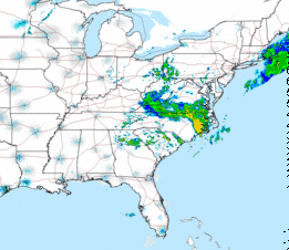
Current radar as of 6:00 PM EDT
Brief Summary:
DET at CLE and MIL at CIN will see a few showers around. VERY LOW CHANCE OF PPD/ANY TYPE OF DELAY
NYY at BLT look like they will luck out this evening. Rain, some of it heavy, will be to their south while a lighter and smaller batch is just to their north. A few showers may drift into the Inner Harbor from time to time as shown below:
7PM simulated radar:
8 PM simulated radar:
As can be seen in the above 2 graphics, rain is modeled to be very spotty in the BLT area. However, this disturbed weather is being caused by a huge area of upper-level low pressure. These systems are notorious for being difficult to nail down where exactly the rain bands will set up. For that reason, I am slightly more nervous about this game than what this model shows and will keep a close eye on it. VERY LOW CHANCE OF PPD WITH A LOW CHANCE OF ANY TYPE OF DELAY. More details to follow as we get closer to the game but right now I am thinking more optimistically than what I was in the original report.
Both of the games in California (NYM at SD and COL at SF) will see the chance of some rain. Not to get too complicated, but we are in a weather pattern which is called an Omega block, where we have a pair of upper level lows (one near the East coast, one near the West coast) with a ridge in the middle. This pattern is also somewhat-famously (by a former colleague of mine) named a Van Gundy after former NBA coach and current NBA analyst Jeff Van Gundy because of how far down his droopy eyes sag with his nose in between them. Let me show on a weather map what is looks like:
That is a 500 mb chart for tonight. The pair of features centered near both coasts is easy to pick out. Why am I telling you all of his? Well, much like I mentioned for the NYY at BLT game above, rain around these systems is very difficult to pinpoint. LOW CHANCE OF ANY PROBLEMS IN EITHER OF THESE LOCATIONS
****PM update: Most of the rain looks to stay north of SF and is basically non-existent near SD so we should be OK *****
Good Hitting Environments:
The added moisture in the air for both NYM at SD and COL at SF may make batted balls be able to carry further than they normally would. Both locations will also see a breeze blowing out.
MIL at CIN will see a breeze blowing out to right.
Poor Hitting Environments:
DET at CLE, WSH at CHC and NYY at BLT will see cool temperatures and a breeze blowing in.
In the scales used below, a 1 greatly favors the pitcher while a 10 greatly favors the batter.
DET at CLE 6:10: SEE BRIEF SUMMARY ABOVE. Wind N 8-16 mph which blows in from center. The wind is a 3. Temps in the low to mid 50s. Air density is a 3.
NYY at BLT 7:05: SEE BRIEF SUMMARY ABOVE. Wind NE 5-10 mph which blows in from center. The wind is a 4. Temps in the low to mid 50s. Air density is a 3.
TEX at TOR 7:07: The retractable roof will likely be closed because of rain and cool temps.
MIL at CIN 7:10: SEE BRIEF SUMMARY ABOVE. Wind N 8-16 mph lessening to 5-10 mph which blows out to right. The wind is a 7 becoming a 6. Temps in the mid to upper 50s. Air density is a 4.
AZ at MIA 7:10: The retractable roof will likely open. West wind 6-12 mph which blows out to left. The wind is a 6. Temps near 80 falling into the low to mid 70s. Air density is a 7 becoming a 6.
WSH at CHC 8:05: Wind NNE 6-12 mph becoming nearly calm. The wind blows in from right early on. The wind is a 4 becoming a 5. Temps in the upper 50s falling into the low 50s. Air density is a 4 becoming a 3.
BOS at CHW 8:10: Wind NNE 6-12 mph becoming nearly calm. The wind blows out to right early on. The wind is a 6 becoming a 5. Temps in the upper 50s falling into the low 50s. Air density is a 4 becoming a 3.
SEA at HOU 8:10: The retractable roof will likely be open. N wind 6-12 mph becoming nearly calm. The wind early blows in from center. The wind is a 4 becoming a 5. Temps in the low 80s falling to near 70. Air density is a 7 becoming a 6.
NYM at SD 10:10: SEE BRIEF SUMMARY ABOVE. Wind SW 8-16 mph which blows out to right. The wind is a 7. Temps in the low to mid 60s. Air density is a 6 or a 7.
COL at SF 10:15: SEE BRIEF SUMMARY ABOVE. Wind SW 8-16 mph with higher gusts. The wind blows out to left. The wind is a 7. Temps in the low 60s falling into the upper 50s. Air density is a 6.


No comments:
Post a Comment