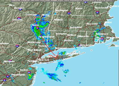
Brief Summary: (6:50 pm update)
****Showers look to miss NYC****
PPD threat: none Delay: STL(slight), MIN (start), TEX (slight), NYY (slight)
Thunderstorms have fired near MIN. Here are the radar and simulated radars for 7, 8 and 9 PM:
**The tstorm west of MIN has weakened a bit just as the models said they should. Makes me optimistic that they will be able to play****
Thunderstorms slid south of STL
The answer is that they SHOULD NOT. The optimism about this game continues but we are not completely out of the woods due to a warm and humid atmosphere that could be the fuel for thunderstorm to refire. But since they already missed and may have "robbed" the atmosphere of much of its energy, I am feeling good about this game now to start on time. Threat of delay below:
7 and 8 PM simulated radars respectively:
*** TOR at NYY A DELAY UNLIKELY. PPD THREAT VERY LOW.****
CHANCE OF A MIDGAME DELAY IS 10%
LAA at TEX will see the threat of a few thunderstorms around this evening. Here is the simulated radar for near scheduled 1st pitch:
You can see that the coverage is sparse and thus A PPD IS UNLIKELY
However, with the popcorn nature of these thunderstorm cells, THE THREAT OF A DELAY IS THERE. WITH THE COVERAGE OF THUNDERSTORMS AROUND 10%, I THINK THAT WOULD BE A GOOD ESTIMATE FOR THE CHANCE OF A DELAY
The thing we will have to look out for is one of the thunderstorm cells stalling and sitting over the stadium. Rather unlikely but that would bring the risk of a PPD.
There is a slight chance, very slight, that a thunderstorm could move into the Windy City and affect KC at CHW VERY late in their game. I will keep an eye on this region and see if anything changes.
Another area I will watch but should not be a problem is SD at SF. A few showers will be around, mainly inland, but should have little or no impact on the game itself.
Good Hitting Environments:
-Warm temperatures with a breeze blowing out to left for CHC at STL and for AZ at PIT.-NYM at WSH will see warm and somewhat humid conditions with a breeze blowing out to right.
-LAA at TEX will see summer-like temperatures and humidity allowing for low air density.
-CLE at CHW and KC at MIN will also see warm temperatures.
Poor Hitting Environment:
-Cool temperatures causing high air density will be found at Fenway for COL at BOS.In the scales used below, a 1 greatly favors the pitcher while a 10 favors the batter. All Times EDT
CHC at STL 7:00: SEE BRIEF SUMMARY ABOVE. Wind S 7-14 mph which blows out to left. The wind is a 6. Temps near 80 falling into the low to mid 70s. Air density is a 7.
TOR at NYY 7:05: SEE BRIEF SUMMARY ABOVE. Wind light and variable which is a 5. Temps in the mid 60s. Air density is a 5.
NYM at WSH 7:05: Wind WSW 6-12 mph which blows out to right. The wind is a 6. Temps in the mid to upper 70s falling into the low 70s. Air density is a 7 becoming a 6.
AZ at PIT 7:05: Wind WNW less than 8 mph which blows out to left-center. The wind is a 6. Temps in the mid 70s falling into the upper 60s. Air density is a 7 becoming a 6.
COL at BOS 7:10: Wind light and variable which is a 5. Temps in the mid to upper 50s. Air density is a 5.
PHL at DET 7:10: Wind WSW 6-12 mph which blows from right to left. The wind is a 5. Temps in the mid 70s falling into the upper 60s. Air density is a 6.
MIL at ATL 7:10: Wind SW less than 8 mph which blows out to center. The wind is a 6. Temps near 80 falling into the mid 70s. Air density is a 7.
LAA at TEX 8:05: SEE BRIEF SUMMARY ABOVE. Wind SSE 8-16 mph which blows in from right. The wind is a 3. Temps in the low/mid 80s falling into the mid to upper 70s. Air density is an 8.
CLE at CHW 8:10: SEE BRIEF SUMMARY ABOVE. Wind SSW 7-14 mph which blows in from right. The wind is a 4. Temps near 80 falling into the low to mid 70s. Air density is a 7 becoming a 6.
KC at MIN 8:10: SEE BRIEF SUMMARY ABOVE. Wind SE 5-10 mph which blows in from right. The wind is a 4. Temps near 80 falling into the mid 70s. Air density is a 7 becoming a 6.
BLT at HOU 8:10: The retractable roof will be closed due to the threat of t-storms.
SD at SF 10:00: SEE BRIEF SUMMARY ABOVE. Wind W 10-20 mph lessening to 8-16 mph which blows out to center. The wind is an 8. Temps in the low 60s falling into the upper 50s. Air density is a 5 becoming a 4.
OAK at SEA 10:10: The retractable roof will likely closed due to the threat of showers.
CIN at LAD 10:10: Wind WSW 10-20 mph which blows out to right. The wind is an 8. Temps in the low to mid 60s. Air density is a 5.


No comments:
Post a Comment